The Caicos theory was proposed in 1947 by Pieter Verhoog, a Dutch
sea captain, and later gained support from Edwin Link, inventor of the Link trainer.
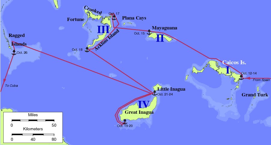
Verhoog's theory has Caicos as Island I, Mayaguana as
Island II, Acklins as Island III, and Inagua as Island IV.
Commodore Verhoog's personal
papers are archived at Georgetown University.
Unresolved problems with the Caicos theory:
- There are no references on old maps to Caicos as Guanahani.
- Caicos comprises five islands. Columbus does not specifically say
that there are five islands in the log.
- Unchallenged historical research indicates that the population of
Guanahani as seen by Columbus was in the 500-1100 range. But extensive
archaeological sites on Caicos suggests a pre-contact population
several times this large.
- The distance from Island I to Island II is reported as five or
seven leagues. The distance from Caicos to Mayaguana is 40 nautical
miles, or at least 13 leagues.
- Island II has a coast running N-S for five leagues. No such coast
at Mayaguana.
- The distance from Island II to Island III is 8 or 9 leagues. The
distance from Mayaguana to Acklins is nearly twice this.
- Columbus reports seeing Island III from Island II. Acklins cannot
be seen from Mayaguana.
- Island III had a coastline more than 20 leagues long. Acklins is shorter than this.
- The coast of Island III runs NNW-SSE. No such coast on
Acklins.
- The harbor at Acklins is not two leagues from the end of the
island.
- The harbor at Acklins does not have two very narrow entrances.
- Columbus sails NW after leaving the harbor at Island III. This
course makes no sense at Acklins, since the harbor is at the NE corner
of the island.
- From the east-west coast of Island III, Columbus steered ESE on the
night of October 17. At Acklins, this course puts him aground on the
Plana Cays.
- Columbus continued his attempted circumnavigation of Island III on
October 18. Theory has Columbus sailing away from Island III to an
unlogged anchorage at Hogsty Reef.
- Columbus sighted Island IV to the east after sailing SE from island
III. Inagua comes into view in the south.
- From within the bight at Island IV, there was a way southwest that
was "very roundabout." There is no such roundabout route in this
theory.
- Columbus's initial course from Island IV was WSW. The theory
requires that Columbus sailed west and WNW to make the Ragged Islands
landfall.
- After leaving Island IV, the theory requires a course change from
WSW to NW not recorded in the log.
- After passing 7 leagues SE of Cabo Verde on Island III, the Ragged
Islands were then 16 leagues farther west. On Verhoog's route, the
Ragged Islands are about 30 leagues from this point, on a course West
by North.

The quote:
"I have never found a single serious objection against
Caicos as the landfall of Columbus in 1492."
-- Commodore Pieter Verhoog
Return to the Landfall Homepage