One of the oldest landfall theories, Cat Island was originally
proposed in the 18th century, before the log of Columbus was
discovered, on the basis of maps which named Cat Island as the
landfall. How those early cartographers got that idea remains an unresolved
mystery.
When Fernandez de Navarrete discovered and published the Diario in 1825,
he also came out in favor of Grand Turk as the landfall. Washington Irving, who was
writing a biography of Columbus, called on U.S. Navy Cmdr. A. S.
Mackenzie for advice on the landfall issue. Mackenzie evaluated the only two
theories of the day, Cat and Grand Turk, and came away favoring Cat. Irving
published Mackenzie's analysis, and as a result the Cat Island theory
enjoyed a flurry of support in the next decade from the likes of Alexander von
Humboldt.
Today the Cat Island theory is all but forgotten, thanks to its many
shortcomings. In particular, the description of Island I (which for some
reason many people place a lot of emphasis on, to the detrement of
other important clues) is rather poor.
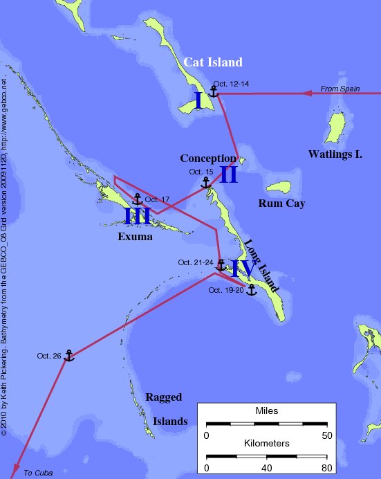
The Cat theory proposes: Island I, Cat Island; Island II, Conception
Island and Northern Long Island; Island III, Exuma Island; Island IV,
Long Island. For the Islas de Arena, Mackenzie proposed not the usual
Ragged Islands, but rather the Mucaras, a group that was charted on the
Great Bahama Bank in the 18th century. Unfortunately for the Cat
theory, the Mucaras do not really exist!
Unresolved problems with the Cat theory:
- Island I was "completely surrounded" by a reef. No such reef at
Cat.
- The surrounding reef enclosed a large harbor. No such harbor at
Cat.
- From his anchorage, Columbus went NNE along the coast of Island I.
No such coastline from Cat anchorage.
- No proposed transatlantic track is compatible with known (or suspected)
magnetic variation in the Atlantic in 1492. Correcting this problem would pull
the end of the transatlantic track southward.
- The map of Juan de la Cosa shows Guanahani as a group of islets,
lying roughly east-west.
- There was a peninsula with a narrow neck at Island I. There is no
such peninsula at Cat.
- Unchallenged historical research indicates that the population of
Guanahani as seen by CC was in the 500-1100 range. But archaeological
and anthropological evidence suggests the likely pre-contact population
of Cat was several times greater than this.
- Columbus reported seeing many islands at various distances after
leaving Island I, some closer than five leagues. No such close islands
from Cat.
- Columbus reported Island II had a coast running North-South. No
such coast at Conception.
- Even if there were such a coast, it would not face Island I, as
reported by Columbus.
- Island II must be at least 5 leagues north to south. Conception is
much smaller.
- Island II must be at least 10 leagues east to west. Conception is
much smaller.
- Columbus reported distance from Island II to Island III as 8 or 9
leagues. Distance from Conception to Exuma is 15 leagues, or from Long
Island is 5 leagues.
- Columbus reported the coastline of Island III runs NNW-SSE. The
coast of Exuma runs NW-SE.
- Columbus reported a harbor two leagues from the end of Island III.
Although there are many anchorages at Exuma, they are farther than this
from either end of the island.
- The two harbor entrances at Island III were both "very narrow" and
separated by a small island. This does not fit Exuma, where the harbor
has many entrances both narrow and wide, separated by many islands
large and small.
- After leaving harbor to the NW, Columbus reported a coast running
E-W. No such coastline at Exuma.
- Columbus did not sight Island IV until 3 hours after leaving island
III. Long Island is already in view from the departure point at
Exuma.
- The coast of Island IV runs west from the northern point. Long
Island runs SSE from the northern point.
- Columbus reported many ponds near Cabo del Isleo (his arrival point
at the northern end of Island IV). There are no such ponds at the
northern end of Long Island.
- From within the bight, there was a way southwest that was "very
roundabout." There is no such southwestern route in this theory.
- Columbus's initial course from the northern end of Island IV was
WSW. This course from Long Island puts Columbus aground on Exuma.
Further, the departure time of midnight seems most unlikely given the
extremely shallow water west of Long.
- The entire proposed leg after leaving Long Island crosses the very
shallow, foul, and dangerous Great Bahama Bank: an unlikely course for
these ships.
- The Islas de Arena seen by Columbus are proposed to be the Mucara
islands -- which do not actually exist!

Return to the Landfall Homepage