The Conception Island theory

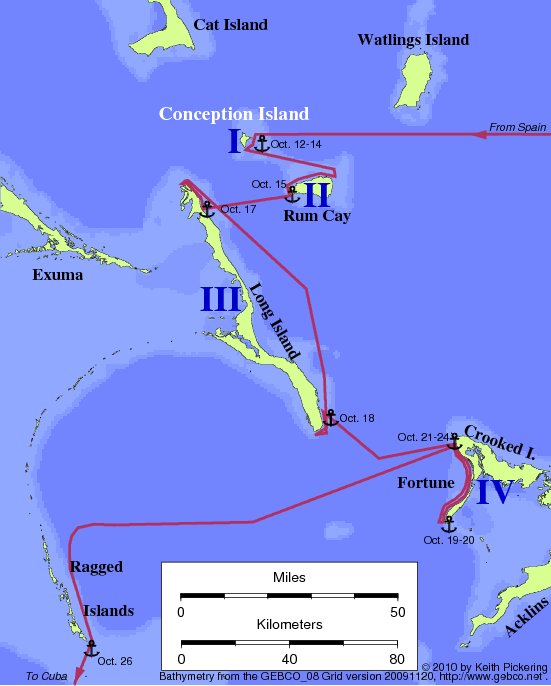
| Map of the Conception Island route (Mitchell 1991) |
| | | |
| |
Conception is a very small (2 square km) island lying in the Long
Island Passage, between Cat Island, Long Island, and Rum Cay. It was
first proposed as the landfall by Lt. R.T. Gould (RN) in 1943, chiefly
as a means of resolving some of the problems with the Watlings theory
(particularly the problem of the light of October 11).
The theory attracted little attention at the time, but was recently
advocated by Dr. Steven Mitchell, a geologist at Cal State Bakersfield,
who had done some archaeological work on the island in the 1980's.
Unresolved problems with the Conception theory:
- Long Island is marginally visible from the Conception anchorage.
Columbus does not mention other visible islands until after leaving
Island I.
- The map of Juan de la Cosa shows a 10 to 15 degree westerly
variation in Hispaniola during 1492-1500; but all transatlantic tracks
ending near Conception require much less than this. Correcting this
problem would pull the end of the transatlantic track southward.
- Unchallenged historical research indicates that the population of
Guanahani as seen by CC was in the 500-1100 range. But archaeological
and anthropological evidence suggests the likely pre-contact population
of Conception was not likely to be this high.
- Island II had a coast running N-S for five leagues. Rum Cay's N-S
coast is less than two leagues.
- Columbus said the N-S coast of Island II was facing Island I. Rum
Cay's N-S coast does not face Conception.
- The N-S coast of Island II was (by clear implication) not
followed.
- Columbus reported Island II had a coast running E-W for more than
ten leagues. Rum Cay's coast is less than four leagues.
- Columbus reported sailing on an E-W course from Island II to island
III. Obvious sailing direction from Rum Cay to Long is WSW.
- Columbus reported distance from Island II to Island III as 8 or 9
leagues. Distance from Rum Cay to Long Island is six leagues.
- CC anchored off the village at Island III. There is no holding
ground off Fish Ponds, Long Island (Mitchell's proposed
anchorage).
- Columbus reported a harbor two leagues from the end of Island III.
Newton Cay harbor (Long Island) is less than half that distance from
the end of the island.
- Columbus's initial impression of the harbor was "marvelous." But at
Newton Cay, a maze of reefs covering the entrance makes approach from
seaward hazardous if not impossible.
- After leaving the harbor on Island III, Columbus sailed NW far
enough to see the entire coastline until the coast turns E-W. At Newton
Cay, the distance run needed to see this far would have been zero.
- After leaving harbor to the NW, Columbus reported a coast running
E-W. No such coastline north of Newton Cay harbor.
- The Historia de Las Indias reports that upon leaving
Island III, Columbus "returned" to Island IV, "which had been left
behind." The Indians wanted to do this in order to get closer to their
home on Island I. These descriptions do not fit the Conception
theory.
- Columbus did not sight Island IV until 3 hours after leaving island
III. Crooked Island comes into view much sooner than this.
- Columbus sighted Island IV to the east after sailing SE from island
III. Crooked island is too far north for this.
- The coast of Island IV does not run west from the northern
point.
- The coast of Island IV is not 12 leagues long.
- After departing WSW from the northern point of Island IV, Columbus
was seven leagues SE of Island III. Departing from the northern point
of Crooked puts Columbus about half this far from Long Island.
- Island IV was eight leagues from Island I. Crooked Island is about
twenty leagues from Conception.
Return to the Landfall Homepage