![]()
At the end of the fifteenth century, celestial navigation was just being developed in Europe, primarily by the Portuguese. Prior to the development of celestial navigation, sailors navigated by "deduced" (or "dead") reckoning, hereafter called DR. This was the method used by Columbus and most other sailors of his era. In DR, the navigator finds his position by measuring the course and distance he has sailed from some known point. Starting from a known point, such as a port, the navigator measures out his course and distance from that point on a chart, pricking the chart with a pin to mark the new position. Each day's ending position would be the starting point for the next day's course-and-distance measurement.
In order for this method to work, the navigator needs a way to measure his course, and a way to measure the distance sailed. Course was measured by a magnetic compass, which had been known in Europe since at least 1183. Distance was determined by a time and speed calculation: the navigator multiplied the speed of the vessel (in miles per hour) by the time traveled to get the distance.
In Columbus's day, the ship's speed was measured by throwing a piece of flotsam over the side of the ship. There were two marks on the ship's rail a measured distance apart. When the flotsam passed the forward mark, the pilot would start a quick chant, and when it passed the aft mark, the pilot would stop chanting. (The exact words to such a chant are part of a lost oral tradition of medieval navigation). The pilot would note the last syllable reached in the chant, and he had a mnemonic that would convert that syllable into a speed in miles per hour. This method would not work when the ship was moving very slowly, since the chant would run to the end before the flotsam had reached the aft mark.
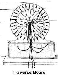 |
Speed (and distance) was measured every hour. The officer of the watch would keep track of the speed and course sailed every hour by using a toleta, or traverse board. This was a peg-board with holes radiating from the center along every point of the compass. The peg was moved from the center along the course traveled, for the distance made during that hour. After four hours, another peg was used to represent the distance made good in leagues during the whole watch. At the end of the day, the total distance and course for the day was transferred to the chart.
Columbus was the first sailor (that we know of) who kept a detailed log of his voyages, but only the log of the first voyage survives in any detail. It is by these records that we know how Columbus navigated, and how we know that he was primarily a DR navigator.
Since DR is dependent upon continuous measurements of course and distance sailed, we should expect that any log kept by a DR navigator would have these records; and this is exactly what Columbus's log looks like. If Columbus had been a celestial navigator, we would expect to see continuous records of celestial observations; but Columbus's log does not show such records during either of the transatlantic portions of the first voyage.
It has been supposed by some scholars that Columbus was a celestial navigator anyway, and kept his celestial records hidden for some unknown reason. (This supposition is necessary to support some theories of the first landfall.) But this hypothesis does not hold water. Columbus's ships were steered by helmsmen at a tiller, below the quarterdeck. The helmsmen could not see the sky, so the only way they could keep a course was by magnetic compass. The officer of the deck had his own compass, and would call down course changes as necessary. This means that the courses used aboard ship (and in the log) would have been magnetic courses.
Now suppose that Columbus was making unrecorded celestial checks on his latitude as he sailed west on his first voyage. In that case, as magnetic variation pulled his course southward from true west, he would have noticed the discrepancy from his celestial observations, and he would have corrected it. In other words, if Columbus were a celestial navigator, we would expect to see a series of small intermittent course corrections in order to stay at a celestially determined latitude. These corrections should occur about every three or four days, perhaps more often.
But that is not what the log shows. On the first voyage westbound, Columbus sticks doggedly to his (magnetic) westward course for weeks at a time. Only three times does Columbus depart from this course: once because of contrary winds, and twice to chase false signs of land southwest. In none of these cases does he show any desire to return to a celestially-determined latitude. This argument is a killer for the celestial hypothesis, and was first made by Rear Admiral Bob McNitt (USN) in 1992.
Well then, could Columbus have corrected his compasses by checking them against the stars -- and thus avoid the need for course corrections? This would have been possible in theory, but we know that Columbus could not have actually done this.
On his return voyage in 1493, Columbus started from Samana Bay on the north coast of Hispaniola, and he made landfall at Santa Maria Island in the Azores. We know all of his DR courses and distances between these two points, since they're recorded in his log. Following these courses and distances using a corrected compass puts Columbus over two hundred miles southeast of the Azores at the time he should be in sight of them. The only way to get from Hispaniola to the Azores using Columbus's recorded courses and distances is to assume that he was using an uncorrected compass, and that he was pulled leftward by westerly magnetic variation in the Atlantic. Applying the same assumptions to the westward voyage shows that Columbus must have been using dead reckoning rather than celestial navigation, because of the absence of course corrections. On the westward passage, this same magnetic variation would have pulled his fleet leftward into the southern Bahama Islands, where most landfall theories put him.
![]()
Click here to return to The Columbus Navigation Homepage.