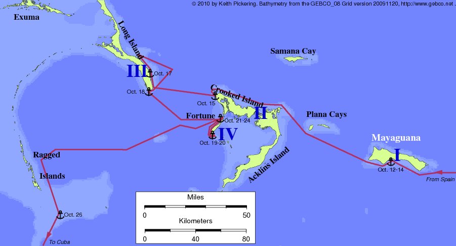
Mayaguana Island lies in the southern Bahamas, west of Caicos and
east of the Plana Cays. It was first proposed as the landfall by
historian Antonio Varnhagen in 1825, and has (unfortunately) attracted
little attention since then. Varnhagen proposed: Island I = Mayaguana;
Island II = Acklins-Crooked; Island III = Long I.; Island IV = Fortune
Island. Varnhagen was the first to use Acklins-Crooked as Island II,
and the first to use Fortune as Island IV.
Since its publication, only Gustavus Fox has dealt with Varnhagen's
theory seriously. Fox rightly criticized the theory's route along the
west side of Long Island. (Varnhagen was apparently unaware that the
waters there are too shallow to be navigable.) For his own Samana Cay
theory, Fox substituted another route up and down the east coast of
Long.
However, it is possible to salvage a pretty good theory from the
Mayaguana landfall by simply using Varnhagen's route from Mayaguana to
Crooked, and Fox's route from Crooked forward -- avoiding the west
coast of Long Island. Thus repaired, the Mayaguana theory has few
weaknesses and many strong points, including a nice surrounding reef,
and by far the best fortifiable peninsula at Island I (see the landfall
clues page). For those who find a multiple-island Guanahani
unacceptable, Mayaguana may be the best alternative. On the scorecard
and in the problem list below, we evaluate this amended theory rather
than Varnhagen's published work.
Unresolved problems with the Mayaguana theory:
- There are no references on old maps to Mayaguana as Guanahani.
- Distance from the likely west coast anchorage to the fortifiable
peninsula is about 25 nautical miles. A round trip of 50 nautical miles
in open boats is unlikely in less than a day.
- Unchallenged historical research indicates that the population of
Guanahani as seen by CC was in the 500-1100 range. But anthropological
evidence suggests the likely pre-contact population of Mayaguana was
around 3000 or more.
- Leaving Island I, Columbus describes 'many' visible islands, some
less than five leagues distant from Island I. There are no other
islands this close to Mayaguana.
- Distance from Island I to Island II was five to seven leagues. The
distance from Mayaguana to Acklins is about three times greater than
this.
- The coast of Island IV does not run west from the northern
point.
- The coast of Island IV is not 12 leagues long.
- Island IV was eight leagues from Island I. Fortune Island is about
twenty leagues from Mayaguana.

Return to the Landfall Homepage