The Egg Island theory

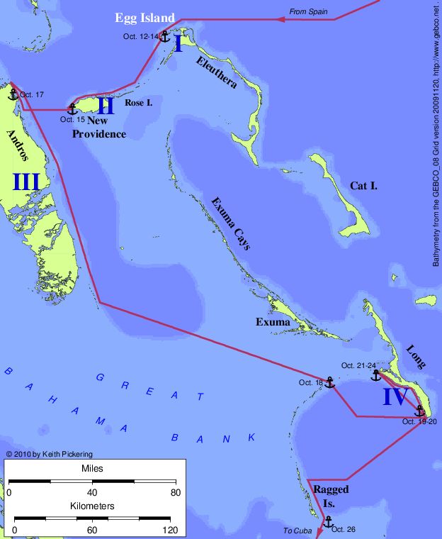
| Map of the Egg Island route (Molander, 1981) |
| |
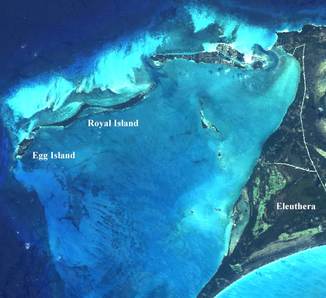
Egg island is a flyspeck of land (0.2 square miles) at the end of a
string of small islands extenting west from the northern end of
Eleuthera Island in the Bahamas. Along with its near neighbor Royal
Island, Egg was proposed as the landfall in 1981 by Arne B. Molander, a
retired civil engineer. Molander has been a tireless advocate for his
theory since, although his efforts so far have not convinced
many that the idea has merit. To read Molander's view of the
landfall,
click here.
The route proposed by Molander: Island I = Egg/Royal; Island II =
New Providence/Rose Island; Island III = Andros; Island IV = Long Island.
One of Molander's creative defenses to his theory's many
shortcomings is what I call the "All Purpose Indian Map Excuse." When
Molander's theory runs counter to what Columbus actually wrote in the
log, Molander simply asserts that Columbus's log entry is wrong because
he was being deceived by an inaccurate map drawn by his Native American
guides.
Although it is clear that the Indians understood maps -- reportedly, they
made a crude map out of beans for King John of Portugal -- there is good
evidence in the historical record that Columbus did not receive cartographic
information from the natives via maps. For example, in Columbus's 1493 letter
to the Spanish Sovereigns, he wrote:
"After I arrived at Juana [Cuba] . . . I thought it was
probably not an island, but rather a mainland . . . but I could not
verify this because everywhere I arrived people fled and I could not
speak with them. . . . In the meantime I already
understood something of the speech and signs of certain Indians I had
taken on the island of San Salvador, and I understood [from them] that
this was still an island."
-- translated by Margarita Zamora
So Columbus needed cartographic information from the Indians, and he
was unable to get it until he had learned their language. Of course, if
the natives had been drawing maps for him, language would have been no
barrier.
| Landsat image of Egg Island |
|---|
 |
| |
| |
| |
Unresolved problems with the Egg Island theory:
- In order to reach Egg Island, Columbus would have had to have been
a celestial navigator. There is unrefuted evidence that Columbus's
navigation was by dead reckoning instead.
- There are no references on old maps to Egg as Guanahani.
- Egg and Royal are two islands. Columbus does not specifically say
that there are two islands in the log.
- Eleuthera Island is marginally visible from the Egg Island
anchorage. Columbus does not mention other visible islands until after
leaving Island I.
- There is no surrounding reef at Island I.
- Island II has no coast running North-South.
- Even if there were such a coast, it would not face Island I.
- Island II must be at least 5 leagues north to south. New Providence
is much smaller.
- Island II must be at least 10 leagues east to west. New Providence
is much smaller.
- The two harbor entrances at Island III were "very narrow." The one
entrance to Conch Harbor (Andros I.) is gigantic.
- After leaving the harbor at Island III, Columbus sailed NW. That
course from Conch Harbor puts Columbus aground on Andros.
- Columbus sailed ESE on the night of October 17. That course from
Andros puts Columbus aground on the Exuma Cays.
- Columbus continued his attempted circumnavigation of Island III on
October 18. The theory has Columbus spending the entire day out of
sight of Andros Island.
- The Historia de Las Indias reports that upon leaving
Island III, Columbus "returned" to Island IV, "which had been left
behind." The Indians wanted to do this in order to get closer to their
home on Island I. These descriptions do not fit the Egg theory.
- The theory requires Columbus to sail at 8 knots (faster than any day's
run on the transatlantic trip) across about 90 miles of the extremely shallow,
dangerous, and uncharted Great Bahama Bank. The wind required for such
a speed (Force 6) would raise enough whitecaps to render impossible any
reconnoitering of the many rocks in this area. As a practical matter
the passage is not possible under these conditions.
- Columbus arrived at Island IV at the northern end. The theory has
Columbus arriving at the western end of Long Island.
- The coast of Island IV does not run west from the northern point. (Nor does
it run west from the point of arrival. As noted above, the northern point is
the point of arrival in the Diario, but not in the theory).
- The coast of Island IV is not 12 leagues from point of arrival to
Cabo Hermoso (using Molander's adopted 2.82 nautical mile league).
- There was a large bight northeast from Cabo Hermoso on Island IV.
The theory's bight is northwest from Cabo Hermoso.
- Columbus reported many ponds near Cabo del Isleo (his arrival point
at the northern end of Island IV). There are no such ponds at Sandy Cay
(his arrival point on Long Island, according to the theory).
- From within the bight, there was a way southwest that was "very
roundabout." There is no such roundabout route in this theory.
- Columbus departed Island IV from northern end. The theory has him
departing from the western end.
- Columbus's initial course from Island IV was WSW. The theory
requires that Columbus initially sailed ESE along the west coast of
Long Island.
- After leaving Island IV, the theory requires a course change from
ESE to SSE not recorded in the log.
- After leaving Island IV, Columbus was 7 leagues from Cabo Verde on
Island III. The theory has him about 10 times farther away than
this.
- Cabo Verde is described as being "in the western part of the
southern part" of Island III. The theory puts Cabo Verde near the
northeast corner of Island III. In fact, in this theory, Columbus never
even sees the western part of Island III. (Nor the southern
part, since it was passed in the dark.)
- Following Columbus's courses and distances after leaving Island IV,
you cannot reach the Ragged Islands unless at least one of the
distances reported by Columbus was wrong.
- Columbus reports that Island IV is 8 leagues from Island I. The
theory's distance is about 5 times greater.
The quote:
"The overwhelming weight of evidence from all sources
points to Egg Island."
-- Arne Molander
Return to the Landfall Homepage