Table 1: Columbus landfall scorecard
Note: Figures 1-8, referred to throughout the text, will be found below. These eight illustrations are based upon modern maps and-or Diario descriptions of the areas in question.
In recent years, the majority of those scholars active in the robust Columbus-landfall controversy have enthusiastically pointed out how their respective theories are a better match with the Diario (the log of Columbus's first voyage to the New World) than the Watlings Island theory supported by many historians, most notably Samuel Eliot Morison.[2] Among the theorists are Arne Molander[3] with Egg Island, Joseph Judge[4] with Samana Cay, Pieter Verhoog with Caicos, Dr. Stephen Mitchell with Conception, Robert H. Power with Grand Turk, and Ramon Didiez Burgos with the Plana Cays. All these theories have, as their purpose, the determination of the location of San Salvador [Columbus's "landfall" --- i.e., sighting of land]; and, as their method, the tracing of Columbus's track to and-or among San Salvador & its neighboring islands.
All tracks proposed to date have inconsistencies (often serious ones) with the distances, directions, and descriptions provided in the Diario. The Diario itself is an abstract of Columbus's centuries-lost original log, prepared by (Fray) Bartolome de Las Casas in the early 16th century; this situation has given rise to a hive of speculations on possible transcription errors, often conveniently located just where they will do a particular theory the most good.
In this paper, I will propose a new track which has fewer inconsistencies and greater fidelity than any proposed thus far; and I will --- in an equitable[5] Columbus Landfall Theory Scorecard (Table 1. above) --- compare this track to other currently popular tracks, with an eye toward rating the various tracks vs. the descriptions in the Diario; and I will show how the Diario is far more internally consistent and error-free than many now suppose.
There are two ways to trace the track to San Salvador: forward from the Canaries, across the Atlantic; and backward from Cuba. The transatlantic track has been traced at least four times in the 20th century: first by John W. McElroy,[6] in support of Morison's work; then in 1986 by Luis Marden,[7] in support of Judge's work. Marden accounted for leeway and drift, which McElroy had not, moving the end-of-track south to the vicinity of Samana Cay; but a year later, Richardson and Goldsmith,[8] using a more precise accounting for leeway and drift, moved the end of track north again to the vicinity of Watlings. All of these analyses were based on an isogonic chart for epoch 1500 which was drawn by Willem Van Bemmelin in 1899.[9] Van Bemmelen's study was based on extremely sparse data, however, and its validity is highly dubious (as Van Bemmelen himself was careful to point out). We know for example that archeomagnetic studies are not precise enough to support this kind of application; the most recent work available[10] indicates that the position of the north geomagnetic pole (NGP) for epoch 1500 can be placed only within a radius of some 400 nautical miles (nmi) at the 95% confidence level. This means that the standard deviation of direction for a magnetic vector at a mean point on the Earth's surface is about 8 degrees; which in turn implies that a single standard deviation for the transatlantic track is about 6 latitude degrees, north or south of the mean end-of-track.[11] In 1991, Goldsmith and Richardson tried again, creating their own isogons (based on the known landfall of Columbus's second voyage in 1493) and using a shorter length league; this placed the end-of-track in the vicinity of Grand Turk Island.[12]
It is clear from this evidence that regardless of what mean end-of-track one chooses, the uncertainties are at present so large that there is no island in the Bahamas which can be eliminated from consideration on the basis of the transatlantic track.
The transatlantic track being unhelpful (without, e.g., more accurate isogons), we are left with the backward track from Cuba. Columbus spent time at four islands in the Bahamas, which he called San Salvador, Santa Maria de la Concepcion, Fernandina, and Isabela; the native names are recorded only for the first and fourth, Guanahani and Saometo, respectively. (It is common for Columbus scholars to refer to these four islands, respectively, by Roman numerals I through IV. See abbreviation-key attached to Table 1.) After leaving Island IV, Columbus stopped at what he called the Islas Arenas, which are today known as the Ragged Islands.
The Ragged Islands constitute the first step in the backward track from Cuba; Ragged is the only Bahama landfall accepted by all (or nearly all) Columbus scholars, and included on the track of nearly every theory. The reason for this wide acceptance is easy to see: the Ragged Islands are in the right direction from Cuba; they are at the right distance from Cuba; and they match Columbus's description of the Islas Arena perfectly --- seven or eight islands in a north-south[13] line. The Ragged Islands pass what I call the "3-D test": right distance, right direction, right description. Any island along the track that passes this test can be considered as close to being proven as it is possible to get.
The next step back from the Ragged Islands is to Columbus's Isabela, Island IV. But here we seem to be stymied almost before we get started: Columbus tells us the direction he sails (west-southwest) when leaving Island IV, but he omits the distance he makes during the day of October 24. However, at dusk Columbus reports that he is 7 leagues southwest of "Cape Verde" (which is "in the western part of the southern part"[14] of Island III). This establishes the so-called Cape Verde fix, and allows us to plot his movements from Island III instead of Island IV. During that night, he makes only two leagues because of bad weather, then makes 5 more leagues the following morning, continuing WSW. At 9 a.m., he turns straight west and makes 11 leagues, at which time he sees the Ragged Islands lying 5 leagues ahead of him.
We now have enough information to compute the distance &
direction (backward) from Columbus's Ragged Islands landfall to Cape
Verde on Island III, using a simple summation of vectors: from island
III, we go seven leagues southeast to the Cape Verde fix, then follow
the fleet seven leagues WSW, and another 16 leagues west. The summed
vector is 19.1 leagues long at a direction 23.5 degrees north of east,
which is quite close to east-northeast. We can now plot this on a map,
if we know how long a league is. The shortest league mentioned by
modern scholars is the 16,240 foot Geometric League (GL) advanced by
James E. Kelley,[15] while
the longest commonly used is the 19,400 foot Portuguese Maritime League
(PML) used by Morison and others. We will use these figures as outside
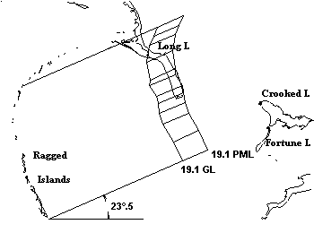
limits in our plot. In Figure 1, I have plotted a box which includes
all points lying 23.5 degrees N of E from (i.e., nearly ENE of) the
Ragged Islands, at any distance which is between 19.1 GL and 19.1 PML.
If we believe Columbus, Cape Verde on Island III must lie inside this
box.
|
|
Figure 1: The plot box shows all points which can be considered 19.1 leagues from the Ragged Islands in a direction 23.5° north of east. Part of Island III should lie in or near the plot box. |
|
|---|---|
Only Long Island lies inside the box. Columbus tells us that Cape Verde is in the southern part of Island III, and only the southern part of Long Island lies inside the box, which is good confirmation. But, just to be absolutely sure, there is one more test to apply: does Long Island match the description Columbus gives of Island III? Does Long Island have a coast at least 20 leagues long? Does Long Island have a coast that runs NNW? Does part of the coast run east-west? The answer is Yes to all these questions. Long Island matches the description in the Diario, it is in the right direction from the previous landfall, and it is at the right distance from the previous landfall; Long Island passes the 3-D test. This runs the Egg Island theory aground, which has Andros as Island III (Andros matches the description, but is in the wrong direction and is hopelessly too far away). Both the Caicos and Grand Turk theories have Acklins as Island III, but Acklins has the wrong distance, wrong direction, AND wrong description, as it has no NNW coast.
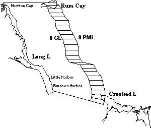
Having determined the identity of Island III, we now work back to Island II, using the same technique and applying the same criteria. The distance from Long Island to the western cape of Island II is 8 or 9 leagues, and the direction is east --- or "almost east-west". In Figure 2, I have plotted 8 GL and 9 PML as the limits of the search box, and have run the box eastward along the coast of Long Island. The box includes part of Rum Cay, but not the western cape. Since there may be uncertainties in Columbus's distance estimates,[16] we cannot positively eliminate Rum Cay with this evidence; but the western cape of Crooked Island is within the box, which should lead us to prefer Crooked.
 |
|
Figure 2: The plot box shows all points between eight and nine leagues east or almost east of Long Island, Island III. The closest point of Island II should lie in or near the plot box. |
|
|---|---|
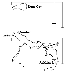
Just to make sure, we will apply our final test. Columbus describes Island II as having a north-south coast five leagues long and an east-west coast of ten leagues or more. In Figure 3, I have superimposed an F-shaped device over a map of Rum Cay, and over the Acklins-Crooked Island group at the same scale; the F shows a 10-by-5-league coastline in both GL and PML. Rum Cay is only a third (or less) the size of Island II; while it is clear that if the north coasts of Crooked and Acklins are considered a continuous coastline, we have a nearly perfect fit. As Gustavus V. Fox has pointed out,[17] the Acklins-Crooked group is the only coast in the central Bahamas that matches this description so perfectly. Acklins-Crooked therefore passes the 3-D test: right distance, right direction, right description.
 |
|
Figure 3: Island II candidates Rum Cay and the Crooked-Acklins group at the same scale. The F-shaped device indicates the size of ten league and five league coasts, using Geometric Leagues and Portuguese Maritime Leagues. |
|
|---|---|
Rum Cay is in the right direction, but is at somewhat the wrong distance and does not even remotely match the size described in the Diario. Mitchell argues[18] that the Diario distances are transcription errors of leagues for miles: that Columbus wrote the length of these coastlines as five miles and ten miles, the "miles" being mistranslated into "leagues" by Las Casas. However, we have two witnesses who both saw the Admiral's own copy of the log and reported on its contents: Las Casas, who transcribed the Diario, and the Admiral's son Fernando Colon, who wrote a biography of his famous father. Fernando's biography records many details of the first voyage lacking in the Diario, showing that Fernando was relying on the original log (not Las Casas's rendition); and Fernando's biography also records the length of these coastlines as five leagues and ten leagues. Thus the suggestion of transcription error by Las Casas is untenable in this instance.
The final step in the backward track is from Acklins to Island I, Columbus's San Salvador. There are two estimates given in the Diario for the distance from San Salvador to Island II: when setting sail on the 14th, Columbus estimates five leagues, but when arriving the next day, he revises this to seven. And the direction is clear: there is only one place in the Diario in which Columbus mentions the direction to San Salvador from any other point. The fleet was detained by tides on the morning of the 15th, and arrives at island II around noon. Columbus describes this island as having a coast running north and south for five leagues, and a coast running east and west for more than ten leagues. But here we arrive at a vital passage that is unaccountably missing from nearly every article and book written about the 1st landfall: for Columbus also says, in that very same sentence, that the coast which runs north-south FACES SAN SALVADOR. For anyone searching for the location of San Salvador, this is arguably the single most important description in the Diario, because this is the only place in the Diario that records the direction to San Salvador from any other point: due east of that five-league-long north-south coast.
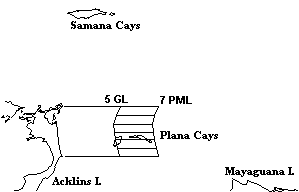
Returning to our backward track, we plot 5 GL and 7 PML, working east from the east coast of Acklins. As seen in Figure 4, only the Plana Cays lie within the plot box. Only Plana is at the right distance and in the right direction to be San Salvador. The western end of the box bisects West Plana, but given the accuracy of his estimates, this is unimportant. The actual distance from his anchorage off the western point of Plana to Northeast Point on Acklins is 4.6 to 5.6 leagues, depending on the league one chooses. As a final test, we check the description. Does Plana have a coast that runs north-northeast? Does Plana have a laguna, reef, and harbor? Yes to all questions; Plana passes the 3-D test. Samana Cay is at the right distance from Acklins, but it is in the wrong direction and does not match the description, since it has no north-northeast coastline. Only Plana is in the right direction, at the right distance, and matches the description. Only Plana can be San Salvador.
 |
|
Figure 4: The plot box shows all points between five and seven leagues east of the north-south running coast of Acklins (Island II). Island I should lie in or near the plot box. |
|
|---|---|
Since Columbus had previously stated his intention to sail southwest when leaving San Salvador, this implies that Columbus changed his mind. As we shall see, Columbus was unsure of his destination on the following day, so this makes perfect sense. When we have such a case as this --- when Columbus's before-the-fact intention disagrees with his after-the-fact description --- the preferred interpretation should ALWAYS be the after-the-fact description. This is especially true when, as in the present instance, Columbus shows doubt in the interim.
Also note that the Diario does not say that the entire east coast of Island II is five leagues long. The Diario addresses only the length of the coast that faces San Salvador. South of Creek Point, the coast of Acklins turns southwest and no longer faces Plana. According to the Diario, the coast of Island II facing San Salvador must have two independent qualities: [a] it must run north-south; and [b] it must be five leagues long. Of those islands that are possible first-landfall sites, only Plana and Grand Turk pass both of these tests. Samana passes neither test; ditto Watlings; ditto Conception; ditto Egg. It is astonishing to find that this critical clue has been ignored by almost every landfall theorist of the 20th century, including (but not limited to) Morison, Judge, Molander, and Mitchell; it is distressing to find that most theorists not only do not attempt to solve the problem, in most cases they fail even to inform their readers that the discrepancy exists.
Fox was one of the few landfall theorists to deal with this problem; in his original paper advocating the Samana landfall, he attempted to dispose of this inconsistency.[19] Fox relied on R. H. Major's suggestion that what Columbus really meant was that the north-south coast faces in the direction that Columbus arrived at Acklins while sailing from San Salvador. This is one of the few times that the Samana theory dips into what David Henige[20] derisively calls Presumably-Columbus-Meant-To-Say thinking --- an infinitely flexible form of logic capable of explaining any discrepancy. Fox further assumed that Columbus was so poor a sailor that he could not compensate for tidal currents, another highly debatable point.