Previous Page
Landfall Homepage
After exploring San Salvador, Columbus returns to his ship, and there follows one of the most intriguing passages in the Diario. "I . . . set sail and saw so many islands that I did not know how to decide which one to go to first . . . . Finally, I decided to go to the largest, and so I am doing. It is about five leagues distant from this island of San Salvador, and the others, some more and some less."[26]
First, it seems strange that Columbus did not know how to decide which way to go, since the previous day he had stated his intention to sail south or southwest to find the source of the natives' gold. And how far would Columbus have had to sail from San Salvador in order to see another island five leagues away? The answer is, no distance at all. Columbus could have seen this second island, at a distance of five leagues, anytime while at anchor during the previous two days(assuming an average height for a Bahamian island).
These apparent inconsistencies are resolved when we realize that Columbus's ships possibly did not have ratlines. Sending a man into the masthead was therefore a difficult operation; the masthead was not a normal watch-standing position, and no one was sent up the mast without a specific reason such as searching for a landfall. It seems likely to me that there just wasn't anyone in the masthead between landfall on the morning of the 12th and setting sail again on the 14th. Setting sail provides a good opportunity to put a man in the mast, because a lookout can ride up on the yardarm as it is hoisted into place. When Columbus set sail that afternoon, he sent a man up --- and while still only a few dozen meters offshore, he had a major shock. He discovered to his surprise that San Salvador was part of a huge and previously unimagined archipelago. Upon questioning his native guides, he found that there were more than a hundred islands in these waters.
That is why Columbus did not know how to decide which direction to take. Eventually, he decided not upon the southernmost nor the southwesternmost island, nor on the island closest to the gold; he decided upon the LARGEST. In other words, faced with this discovery, he temporarily put aside the idea of gold, and sailed instead to find new lands for his sovereign.
Columbus's description of his dilemma on the 14th certainly is interesting and useful, but nowhere that day does Columbus tell us the direction in which his destination island lies. This turns out to be a minor point, however, because after arriving the next day, he neatly fills in the gap.
After arriving at Island II on the 15th, Columbus says, "I found that the face which is in the direction of San Salvador runs north-south and that in it there were five leagues; and the other, which I followed, runs east-west."[27] If the north-south coast faces San Salvador, and the east-west coast by implication does not face San Salvador, it is clear that San Salvador can lie in only one direction: due east of that five-league-long north-south coast. Only Plana and Grand Turk receive full marks on this point. Ramon Didiez Burgos, the first to propose Plana as San Salvador, has Columbus's anchorage on the night of the 15th on the north shore of Crooked.[28] I prefer Judge's route around Bird Rock to Landrail Point (see Figure 3), in view of the wind shift to the southeast which threatened the anchorage.
Columbus sails from Island II, which he names Santa Maria, to an even larger Island III that he calls Fernandina. He estimates the distance between the two islands at nine leagues at first, then revises it to eight leagues "almost east-west". He says on the 16th that this coastline "may" be more than 28 leagues, but on the next day, after actually exploring it, he says that he saw only 20 leagues, and "it did not end there". The east coast of Long is 22 leagues, using James E. Kelley's 2.67 nmi league. The Grand Turk theory requires us to believe that Columbus sailed from Mayaguana to Acklins, across some 40 miles of open ocean, and MISTOOK IT FOR A COASTLINE.[29] This is the kind of explanation that rates a 0 on the Scorecard.
One of the objections to the Plana-Samana route is that Columbus says that Island III is visible to him while he is still at Island II. This seems to be in contradiction to his later assertions that the distance between the two islands is 8 or 9 leagues. However, this is not necessarily the case. If Columbus anchored along Landrail Point on the night of the 15th, he would have had to sail around the western end of Crooked Island. Since the caravels were faster ships than the Santa Maria, it is possible that one of them went far enough into the Crooked Island Passage to make out the island. Or, Columbus might have learned of the island from the Indians: at one point, he says he has an "indication" ( amuestra)of the island's presence.
Didiez Burgos shows Columbus circumnavigating Long Island, which seems particularly unconvincing to me; again, Judge's track along the east coast of Long is far superior. Columbus describes a harbor 2 leagues from the end of Island III. The harbor has two narrow entrances separated by an isleo, or small island: a description that fits Little Harbor(Figure 2) passably well, although Little Harbor has two small islands in the entrance. Fox identified Burrows Harbor, slightly farther south, as this harbor. Fox's harbor has two mouths, but it is only about half the correct distance from the end of the island. In my mind, either of these harbors is a better fit than the Newton Cay harbor at the northern tip of Long, which is the candidate of the Watlings and Conception theories; this harbor is far too close to the northern end of the island. The Egg Island theory has this harbor at Conch Sound on Andros, which has only one wide opening. Caicos-advocates use Lovely Bay on Acklins, which has many wide openings instead of two narrow ones; and the Grand Turk theory uses Abraham's Bay on Mayaguana, which has two openings but no isleo. Columbus sails NW from this harbor "as far as the coast that runs E-W", which is another problem for the Watlings-Conception theories, since there is no such E-W coast, nor any coast at all, north of Newton Cay.
On the evening of the 17th, the Fleet runs into foul weather. Columbus heads for the southern cape of the island to anchor; as the wind was northwest, this cape would have afforded shelter. He spends the 18th continuing around the island when the weather allows; he anchors when it does not, mentioning that "I did not go ashore". In moderate winds, Columbus would have reached South End on Long Island about midday, and spent the afternoon (or part of it) beating northward a few miles along the west coast of the island. This is slow, wind-in-your-face sailing, and Columbus had only a few daylight hours before he was forced to give up and return to the only available anchorage, near South End. The Egg Island theory requires us to believe that Columbus spent this entire day out of sight of land, sailing at top speed through the treacherous shoals between Andros and Long, anchoring in the Jumentos Cays. In a similar fashion, the Caicos theory also requires Columbus to sail away from Fernandina on the 18th, in direct contradiction of the Diario. The reason: there are only 6 hours of sailing from Island III, Fernandina, to Island IV, Isabela, and these theories require extra time to make the distance. No mere transcription error can save these theories here; one must instead assume that Columbus just did not know what he was talking about when he wrote the entry of the 18th. This is again the kind of discrepancy that rates a 0 on the Scorecard.
Columbus sets sail the next morning, spreading the fleet from ESE to SSE; after three hours, he makes his landfall at Isabela, Island IV. Nowhere does Columbus tell us the distance between Isabela (IV) and Fernandina (III). But let us make some reasonable assumptions: the maximum speed in the transatlantic crossing was 3 leagues per hour, thus, Columbus could have been no more than 9 leagues from Island III when he made his Isabela (IV) landfall. Next, if we take the shortest reasonable length for the league (2.67 nautical miles) and the highest reasonable height for a Bahamian island (50 meters), then --- using 15 m as the height of the ship's observer --- we conclude[30] that Island IV could have been as much as 8.6 leagues distant at landfall. So the maximum distance from Island III to Island IV is 17.6 leagues, although it could well be less than this.
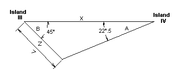
Now, Columbus mentions that the northern end of Isabela (island IV)is on an E-W line from Fernandina (Island III); there is reason to doubt that this is precisely true, but let us assume for the moment that it is. When Columbus departs Isabela (IV) on the 24th,he sails WSW from its northern point, for an unspecified distance, until he sees Cape Verde, the southern point of Fernandina (III), lying7 leagues to the NW (see Figure 6). All right now, trigonometry[31] fans: if the angle A in Figure 6 is 22.5 degrees, and angle B is45 degrees, and side Z is 7 leagues, what is the length of side X? The answer: 16.9 leagues.
|
|
Figure 6: Columbus left Island IV on a WSW course, reaching a point seven leagues SE of Cape Verde on Island III. If Island IV is directly east of Cape Verde, distance X must be 17 leagues. |
|
|---|---|
Striking. We have now calculated the distance from Island III to Island IV in two completely different ways (F11 & F12), and have arrived at answers that agree within less than a league: 16.9 leagues & 17.6 leagues. I must again (as at F11) point out that this distance could be less than the mean result, 17 leagues (indeed, by our Plana track, it is c.10 leagues, Long-to-Fortune: G1 [b] or Figure 8), since Columbus sailed from III towards IV on a SE & then E course, for under 6 hours, and likely he was making less than 3 leagues per hour. But it could not be greater than 17 leagues, since this would require Columbus to have sailed NE from III, in contradiction to the Diario, and at speeds greater than 3 leagues per hour, which is most unlikely.
It is this beautiful internal consistency of the Diario that does in the Caicos theory, the Grand Turk theory, and the Egg Island theory. Each of these theories requires far more distance from island III to Island IV than the Diario allows. The Egg Island theory assumes that the 7 leagues to Cape Verde is a transcription error for 70 leagues. And indeed, if one assumes that Columbus was estimating the direction from a 16-point compass instead of a 32-point, a portion of northeastern Andros just does meet this criterion. However, this does not help much, since Columbus also says that Cape Verde is in the western part of the southern part of Island III, and the Egg Island theory must here put Cape Verde in the eastern part of the northern part of Island III. In other words, one must assume the existence of three separate transcription errors in the same sentence in order for the theory to fit the Diario.
Twice our Plana theory rates a 0 on the Scorecard regarding Columbus's description of Island IV, Isabela, called Saometo by the natives. When Columbus arrives at the northern tip of Island IV, Cabo del Isleo, he notes that the coast from there runs west [which sounds prima facie unlikely if there IS a north tip] for 12 leagues, to a cape called Cabo Hermoso. Here it proves impossible to take the Diario at face value. Consider the following: [a] The north point of Island IV is on a west-to-east course from Island III, or maybe (as suggested by the sailing directions from III to IV: F11) rather south of east; [b] Columbus reached this point in less than 6 hours, sailing approximately east-southeast (idem), suggesting that the actual III-to-IV distance is most likely in the range of 10 to 12 leagues (which is indeed about the distance from Long to Fortune: Figure 8); [c] from the north point of Isabela, the coast runs west for 12 leagues. So it seems that the coast that runs west from Isabela must intersect or almost intersect Fernandina, yet it took 3 hours of sailing even to see the island.
Clearly there is an error here, and there have been many attempts to explain it. Oliver Dunn and James E. Kelley have suggested[32] that gueste (west) is a mistranslation of sueste (southeast), which supports the Watlings-Conception identification of Crooked Island as Island IV.
There is further reason to believe that the coast cannot actually run west from Cabo del Isleo to Cabo Hermoso. First, if the coast actually runs west, how is it that Columbus, on an easterly course, arrives at Island IV at Cabo del Isleo without first coming to Cabo Hermoso? Second, if the coast runs west from Cabo del Isleo, how is it that when Columbus departs from Cabo del Isleo on the 24th, he sails WSW, and yet does not run aground on that coast? Yet Columbus says that Cabo Hermoso is in the western part of the island.
This is one of the few times when the Diario shows an internal inconsistency, and the best way to resolve it is to suppose that the coast runs southwest, not west, from Cabo del Isleo to Cabo Hermoso. This solves the problems of the approach and the departure, while allowing Cabo Hermoso to remain in the western part of the island. The idea is reinforced by an interesting observation: on the evening of the 19th Columbus anchors for the night at Cabo Hermoso, yet on the following morning, the 20th, he weighs anchor from another cape, Cabo del Laguna. Dunn and Kelley have pointed out that the best explanation of this is the supposition that Cabo Hermoso and Cabo del Laguna lie very close to each other;[33] and Cabo del Laguna, Columbus tells us, is at the southwestern end of Isabela. We therefore require a transcription error in the Diario, not to make the Diario match the Plana theory, but instead to make the Diario match itself. The coast from Cabo del Isleo runs southwest, not west, to Cabo Hermoso.
Plana also rates a 0 on the Scorecard in the distance from Cabo del Isleo to Cabo Hermoso, given by Columbus as 12 leagues. Here, for the first and only time in this paper, we require a numerical transcription error to make the Diario match the theory. Perez[34] suggests that doze (twelve) is a mistranscription for dos (two); this fits if you believe that Isabela is the modern Fortune Island, since the south coast of Crooked extends west from the north point of Fortune for about this distance. In other words, a single letter of the original log was miscopied or illegible to a transcriber.
With these corrections, the log reads that from Cabo del Isleo, the northern point of Isabela, the coast runs southwest two leagues to Cabo Hermoso, and Cabo del Laguna lies nearby at the southwestern end of the island. This description matches Fortune Island, Island IV of the Plana-Samana track.