The Watlings Island theory

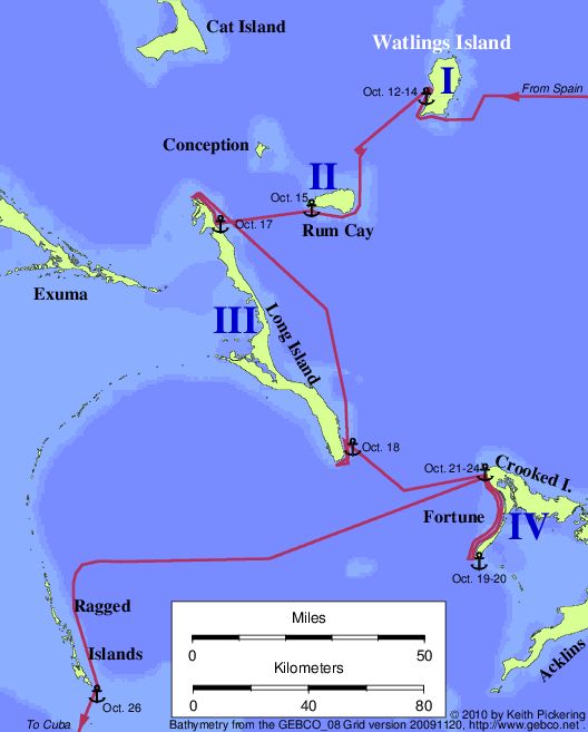
| Map of the Watlings Island route (Murdock 1884, Morison 1942) |
| |
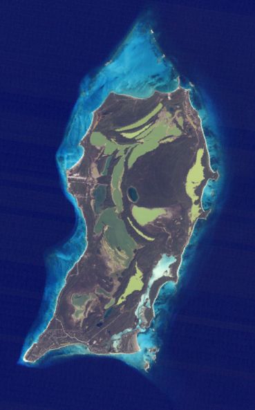
| Landsat image of Watlings Island |
|---|
 |
| |
| |
| |
Watlings Island was the favored landfall theory for most of the
19th and 20th centuries. In 1926, Fr. Chysostom Schreiner convinced
the Bahamian parliament to officially renamed Watlings Island to "San
Salvador, or Watlings Island", and you will see the island called San
Salvador on most maps today. Don't let that fool you, though: as a landfall theory,
Watlings only gained traction because it was better than the 19th century favorites
Grand Turk and Cat Island
(which are among the worst theories around).
Today the Watlings theory is outmoded, problem-riddled, and unfashionable.
There have been many different routes proposed for Columbus starting
from Watlings, beginning with the theories of A.B. Becher in 1856 and
J.B. Murdock in 1884. But the most widely quoted view has been that
championed by Samuel Eliot Morison in 1942, which was essentially a repeat
of Murdock's route. Since then, a number of
people (notably Mauricio Obregon and William Dunwoody) have tinkered
with the route in order to try and resolve some of the problems listed
below. The Murdock-Morison identifications: Island I = Watlings; Island
II = Rum Cay; Island III = Long Island; Island IV = Crooked/Fortune Island.
Dunwoody substitutes Fortune Island (alone) as Island IV, a notable
improvement.
If the problem list below seems longer than some other theories,
that may be just because I've studied this theory in greater detail
than some others. (And believe me, Becher's 1856 route is far worse than Murdock's).
Active support for the Watlings theory collapsed in
the spring of 1996, after the
Leagues-versus-Miles dispute was resolved in favor of leagues.
Unresolved problems with the Watlings theory (Murdock-Morison
route):
- The map of Juan de la Cosa shows a 10 to 15 degree westerly
variation in Hispaniola during 1492-1500; but all Watlings
transatlantic tracks require much less than this. Correcting this
problem would pull the end of the transatlantic track southward.
- No proposed Watlings transatlantic track is compatible with a
W-by-S isogonic rhumbline from Hierro to Dominica, as CC sailed on the
second voyage. Correcting this problem would again pull the end of the
transatlantic track southward.
- Columbus saw a light on the night of October 11. Theory has no
place for such a light to be.
- The map of Juan de la Cosa shows Guanahani as a group of islets,
lying roughly east-west.
- Columbus's boat trip went al luego dla Isla, which means
(according to leading expert Consuelo Varela) "the length of the
island." At Watlings, boat trip goes less than half the length of the
island.
- Columbus explored "the other part, which is the eastern part" of
Guanahani by boat on October 14; at Watlings, the entire exploration is
along the W and N coasts, and is in the northern quadrant from the
Fernandez Bay anchorage.
- Columbus reported a reef completely surrounding "that island" at
Island I. Reef does not completely surround Watlings, and Columbus
would have known this.
- Columbus reported the entrance through the reef was "very narrow."
At Watlings, the reef gap is 1400 meters wide.
- Historical research indicates that the population of
Guanahani as seen by Columbus was in the 500-1100 range. But
archaeological and anthropological evidence suggests the likely
pre-contact population of Watlings was around 2000 or more.
- Columbus reported seeing many islands at various distances after
leaving Island I, some closer than five leagues. From Watlings, only
Rum Cay is visible, and it's farther than five leagues.
- Island II had a coast running N-S for five leagues. Rum Cay's N-S
coast is less than two leagues.
- Columbus said the N-S coast of Island II was facing Island I. Rum
Cay's N-S coast does not face Watlings.
- The N-S coast of Island II was (by clear implication) not followed.
Morison has Columbus following this coast. (William Dunwoody fixes this problem
by sending CC along the north coast of Rum Cay rather than the south coast.
But that means he would not have been able to see and report the length of the east
coast of the island, which he did. So there's no easy way around this problem.)
- Columbus reported Island II had a coast running E-W for more than
ten leagues. Rum Cay's E-W coast is less than four leagues long.
- Columbus reported sailing on an E-W course from Island II to island
III. The obvious sailing direction from Rum Cay to Long Island is WSW.
- Columbus reported the distance from Island II to Island III as 8 or 9
leagues. The distance from Rum Cay to Long Island is six leagues.
- Columbus anchored off a village at Island III. There is no
holding ground off Fish Ponds, Long Island (Morison's proposed
anchorage).
- Columbus reported a harbor two leagues from the end of Island III.
Newton Cay harbor (Long Island) is less than half that distance from
the end of Long Island.
- Columbus's initial impression of the harbor was "marvelous." But at
Newton Cay, a maze of reefs covering the entrance makes the approach from
seaward hazardous if not impossible.
- After leaving the harbor on Island III, Columbus sailed NW far
enough to see the entire coastline until the coast turned E-W. At Newton
Cay, the distance he would need to run to see this far would have been zero.
- After leaving the harbor to the NW, Columbus reported a coast running
E-W. There is no such coastline north of Newton Cay harbor.
- The Historia de Las Indias reports that upon leaving
Island III, Columbus "returned" to Island IV, "which had been left
behind." The Indians wanted to do this in order to get closer to their
home on Island I. These descriptions do not fit the Watlings
theory.
- Columbus did not sight Island IV until 3 hours after leaving island
III. Crooked Island comes into view much sooner than this.
- Columbus sighted Island IV to the east after sailing SE from island
III. Crooked island is too far north for this.
- The coast of Island IV does not run west from the northern
point.
- The coast of Island IV is not 12 leagues long.
- After departing WSW from the northern point of Island IV, Columbus
was seven leagues SE of Island III. Departing from the northern point
of Crooked puts Columbus about half this far from Long Island.
- Island IV was eight leagues from Island I. Crooked Island is about
twenty leagues from Watlings.
The quote:
"There is no longer any doubt that the island called
Guanahani, which Columbus renamed after Our Lord and Saviour, was the
present San Salvador or Watlings."
-- Samuel Eliot Morison
Return to the Landfall Homepage